From July 23 to 25, Ocean University of China (OUC), in collaboration with Tongji University, deployed a Wind3D 10K 3D Scanning Wind Lidar on “Tongji Hai-1,” a multi-tiered integrated observation tower in the East China Sea. The instrument subsequently collected continuous wind-field observations as Typhoon Dolphin, the 13th typhoon of 2026, crossed the East China Sea and made landfall. It is currently operating stably, with data transmitted reliably in real time, providing important observational support for research on typhoon wind-field structure, boundary-layer processes, and typhoon-ocean interactions.
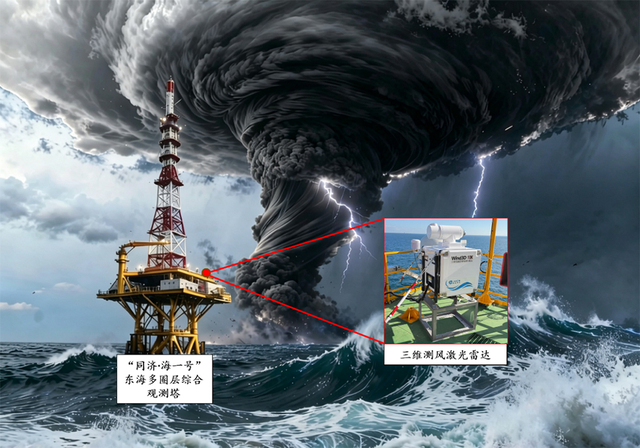
The Wind3D 10K 3D Scanning Wind Lidar is an advanced atmospheric sensing instrument independently developed by a team led by Professor Wu Songhua of the Faculty of Information Science and Engineering at OUC. It is capable of long-range, high-precision wind field measurements. The instrument can measure a range of meteorological parameters at different heights, including radial wind speed, horizontal wind speed and direction, vertical wind speed, and wind shear, enabling fine-scale observations of atmospheric wind-field structures over the ocean. With its high spatiotemporal resolution and continuous monitoring capability, the instrument can capture changes in wind speed and direction, as well as the evolution of wind-field structures, under the influence of hazardous weather events such as typhoons and severe convective weather. It thus provides important observational data for research on typhoon wind-field structures, boundary-layer processes, and typhoon-ocean interactions.
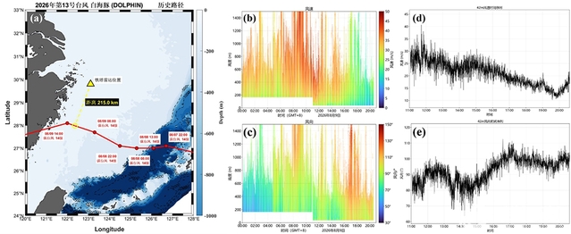
As Typhoon Dolphin affected the region, the wind lidar successfully collected data on the intense wind field associated with the typhoon as it crossed the East China Sea and made landfall. At its closest approach, the center of Typhoon Dolphin passed approximately 215.0 km from the “Tongji Hai-1” observation tower. The lidar continuously monitored the wind field at heights ranging from 42 to 4292 m, with a vertical resolution of 15 m and a temporal resolution of 1 s. The maximum wind speed recorded within this height range was 58.25 m/s at 11:42:55 on August 9. At a height of 42 m, the maximum recorded wind speed was 40.64 m/s at 11:42:23. These observations provided a relatively complete record of changes in the offshore wind field at different heights during the typhoon, yielding valuable in situ observational data for studying the structure and evolution of nearshore typhoon wind fields.
In the future, using the “Tongji Hai-1” observation tower as a platform, the research team will continue to deploy quantum lidar, Raman lidar, and air–sea interface flux measurement instruments. These instruments will provide comprehensive, fine-scale, real-time observations of typhoon structures, processes, and mechanisms across the far field (on the order of 100km), mid-field (on the order of 10km), and near field (on the order of 1km), providing observational data to help advance typhoon research and forecasting in China.