On November 1, 2025, a research team led by Professor Liu Yang from the College of Fisheries at Ocean University of China (OUC) published their latest findings in the ISPRS Journal of Photogrammetry and Remote Sensing in an article entitled “Mapping subtle-featured oyster rafts with high-resolution imagery and deep learning techniques”. This study provides key technological support for the refined management of China’s offshore aquaculture and is expected to help address long-standing challenges in regulation, including low supervision efficiency and insufficient monitoring accuracy. The findings have also been promoted for industrial applications. The technology “oyster farming spatial planning and rights-confirmation supervision and evaluation technology based on satellite remote sensing” was selected as one of the 2025 Excellent Scientific and Technological Achievements in New Fisheries Technology Awards by the National Fisheries Technology Extension Center and the China Society of Fisheries.
Aquaculture plays an irreplaceable role in ensuring food security, driving the fisheries economy, and improving the livelihoods of coastal communities. However, with the continuous expansion of offshore aquaculture, farming facilities are often laid out in a disordered manner, and conventional regulatory approaches face prominent challenges such as limited spatial coverage, delayed data updates, and insufficient detection accuracy, which are no longer sufficient to meet the practical needs for refined management. In recent years, rapid advances in remote sensing imagery and image-classification algorithms have opened up new avenues for identifying offshore aquaculture areas, and related research has grown rapidly. A review of existing studies, however, shows that most work still focuses on large-area, coarse-scale surveys of farming zones and cannot accurately extract key information such as the location, appearance, and scale of individual farming structures. This “macro over micro” research pattern has greatly constrained the application of satellite remote sensing in fine-scale management scenarios such as dynamic monitoring of offshore aquaculture facilities and inspection of illegal sea use, preventing the technology from fully realizing its advantages.
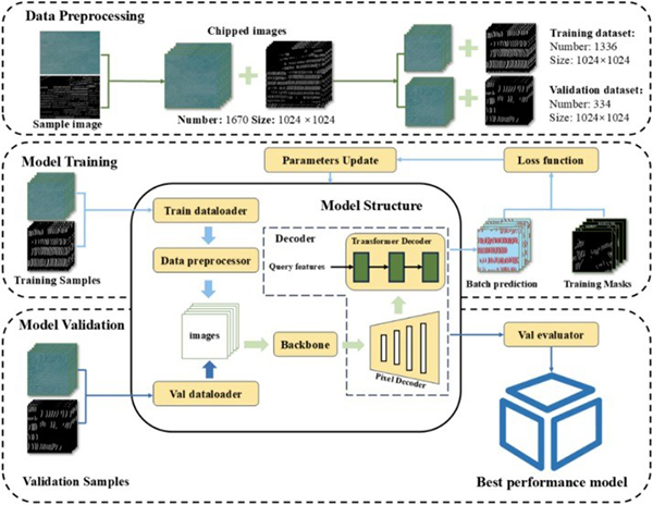
To address these challenges, Professor Liu Yang’s team carried out targeted research. Using high-resolution imagery from the Jilin-1 satellite constellation as the primary data source, the team developed and trained a deep-learning semantic segmentation model to tackle the core challenge of accurately identifying subtle-featured oyster rafts in complex marine environments. Compared with previous studies, this work achieves breakthroughs in three main aspects:
First, a leap in recognition accuracy. The team built a semantic segmentation model with a Swin-Transformer encoder, effectively overcoming the technical bottleneck of traditional convolutional neural networks, namely their limited receptive field and difficulty in capturing contextual information. Leveraging a self-attention mechanism, the model can fully link global image context with local details, enabling precise identification of oyster rafts with weak optical reflectance and indistinct texture features. It maintains stable recognition performance even under challenging conditions such as waves, cloud cover, and changes in lighting conditions. On the test dataset, the model achieved an extraction accuracy of 88%, significantly outperforming conventional deep-learning models such as UNet, and thus laying a solid technical foundation for the precise positioning of individual aquaculture structures.
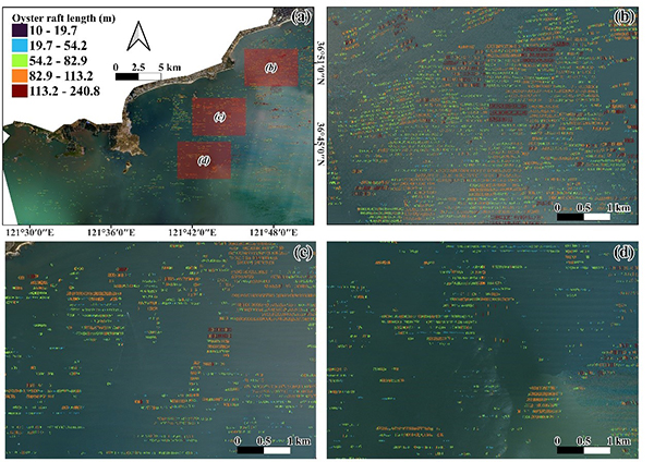
Second, a breakthrough from area-level recognition to individual-raft extraction. Powered by the high-accuracy model, the team, for the first time, achieved single-raft-level extraction of oyster rafts under complex marine environments. In a case study and field verification in the coastal areas of Rushan city, Shandong Province, the model successfully identified more than 40,000 individual oyster rafts and accurately derived key parameters such as the length and distribution density of each raft. The analysis also identified a number of abnormal rafts with unusual lengths scattered around the margins of the aquaculture areas. Further investigation revealed that these anomalies were mostly associated with irregular human operations (such as inadequate facility maintenance) or natural forcing (such as deformation or displacement caused by wind and waves), indicating abnormal farming conditions. These results provide precise data support for subsequent monitoring of the structural health of aquaculture facilities and for early risk warning.
Third, providing a practical pathway for refined regulation and sustainable development. The raft-mapping results from this study make it possible to rapidly and accurately identify oyster rafts that extend beyond designated farming zones or encroach upon other marine functional areas, such as navigation channels and marine protected areas. The outcomes can be directly used by marine management authorities to investigate and rectify illegal sea use, help regulate farmers’ lawful use of sea areas, and effectively reduce problems such as waste of marine space resources and damage to the marine ecological environment caused by disordered farming. This technology provides a strong technical support for the standardized and sustainable development of the oyster aquaculture industry in Rushan.